|
White Sands News
WHITE SANDS FLOODED IN APRIL 2007
Photo:
Tory Davis
The National Park Service informs:
|
|
Park Closures
Due to missile testing on the adjacent White Sands Missile Range, it is
occasionally necessary, for visitor safety, to close the Dunes Drive for
periods of up to three hours. The park Visitor Center and Gift Shop remain
open during missile range closures. Visitors on a tight schedule should
contact the park the day before arriving to check on closures (575)
679-2599. |
U.S. Highway 70 between White Sands National Monument and Las Cruces may
also be closed during times of missile testing. For US 70 closure
information, call (505) 678-1178.
All closures are subject to change
without notice.
Check NPS website
October 2, 2011 — White Sands Visitor
Center Gets Makeover
New exhibits catch the interest of young and old. Enjoy watching the
clip "A Land in Motion" in HD. Didn't know about the tropical sea that
once covered the area? What? Sharks once cruised across New Mexico?
Come and visit White Sands National
Monument Visitors Center.
Habla español? Bring your abuela, stay
tranquilo, and enjoy all displays because todo is bilingual.
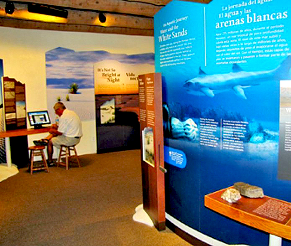
New Exhibits: White Sands
Visitor Center
Photo: NPS
December 29, 2008 — Don't visit White
Sands National Monument on the morning of this Monday because it will be
closed from 9 until 1pm. The reason? The Monument will get a new
entrance.
Come at 1 pm and you will be fine.
April 21, 2008 — White Sands National
Monument has a new superintendent. Kevin Schneider starts his new job in
mid-May. Read
more about Kevin here.

KEVIN SCHNEIDER
NEW SUPERINTENDENT AT WHITE SANDS
June 15, 2007 - No more flooding. The
entire park is open to visitors again.
Check visiting hours and fees ON the park's official site.
May 2, 2007 - There seems to be more in
store for the Sands, weather wise.
This nice tornado has been spotted today:
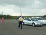
Funnel cloud over White Sands
Photo: Jo Dell Vaughn
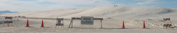
April 2007 - Part of the Monument is
still closed off due to flooding.
However, you are still able to visit
and see quite a bit. See map below for the closed off section.
It looks that the heavy rainfall in August 2006 raised the water table and
the water is still seeping up. This keeps the ground too
mushy to drive on.
For an update call (575)-679-2599.
Here's the area that was closed of in April 2007:
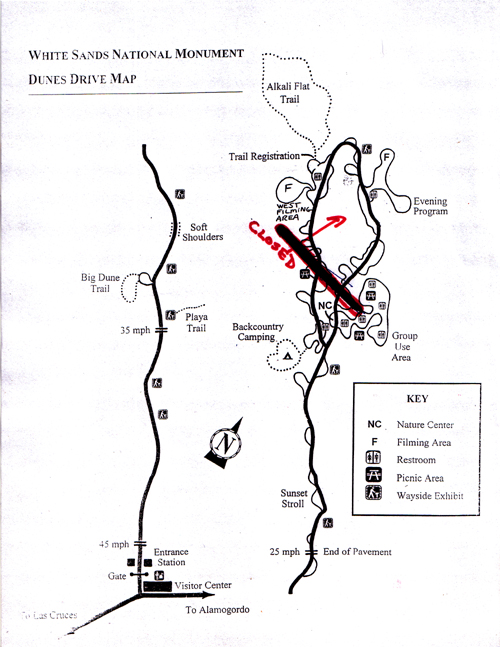
WHITE SANDS CLOSED OFF AREA - MARCH 27
The fine folks at White Sands National
Monument were so kind to answer a few questions you might have regarding
the flooding:
How much of the Park is closed at
this time?
Right now, 2/3 of the picnic loop is under water, or covered in very wet
gypsum, similar to mud in consistency.
When did the flooding trouble
start?
Much of the flooding began in the wake of heavy rains we received in
August 2006. In that month, we received about 12 inches of rain. Flooding
in one picnic area has been present since late June 2006.
Has it flooded this badly before? When?
The last time the picnic loop was under water was in the winter of 1992
following heavy rains in December 1991. Flooding conditions lasted until
Easter 1992. As a matter of record, 2006 was the wettest year for White
Sands since 1941.
What can be done to prevent it from
happening again?
Nothing. White Sands lies at the lowest point of the Tularosa Basin. The
basin has no outlet for the water it receives, so the water that falls
within the basin and its surrounding mountains stay here. The water then
flows, both above and below ground, to the lowest point. The ground under
the dunes consists of clay, about 25 feet below the surface, so the water
cannot be absorbed or pumped somewhere else, it must evaporate.
When is the situation expected to get
back to normal again?
The best guess we can give, based on the rate of evaporation and repair to
the surface, is mid summer 2007. Moreover, that assumes a normal monsoon
season.
To the best of our knowledge all
information is current. If you should discover any errors, however,
please let us know. Thanks!
|